How to use this blog.

After each lesson or group of lessons I will write the aims and a brief summary of what the lesson covered on the blog. There will also be links to useful websites and videos to help you revise throughout the year.
Exam questions and ideal exam answers will also be posted and you can answer the questions online.

Thursday, May 29, 2014

Yr11 - Great map found by Zane and Brodie!

http://www.nzta.govt.nz/projects/basin-reserve/img/pl-option-a.jpg

Will be very useful when explaining the location of the Basin Reserve

Yr11 - Just because it's a great photo!


The photo below shows cars during rush hour in Miami. Each red circle contains 70 passengers.

Just shows you what a difference using the bus can make!

World on the brink of another great Extinction.

A very depressing article on the current rapid rate of extinction. Human actions are causing more and more animals and plants to disappear forever from our planet.

Apparently there is hope though.

Link to article in Huffington Post.

Could be useful for looking at global patterns or issues.

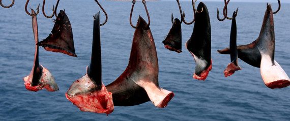
SHARKS

Tuesday, May 27, 2014

As the Climate Changes will we have to plan for more Evacuations?

The link below takes you to a great article which discusses how large cities will have to plan for more evacuations in the future as more extreme weather occurs.

It talks about what happened after Hurricane Katrina hit New Orleans and how they can try to make sure next time something similar happens they can make sure everyone is able to reach safety.

Very useful for Level 1 Extreme Natural Events but really just interesting for everyone to read!

Image

Article on the future of evacuations in the climate change era


Yr13 - The Regulators and Tourist Industry in Rotorua

The slide show below goes through the main features of the Tourist Industry in Rotorua and the Regulators that control the Industry.


Yr13 - Factors that influenced the growth of Rotorua - these are not in order!


Facilities were basic and main attractions were geothermal (the pink and white terraces).
Government infrastructural developments (like the airport and upgraded roads) created better accessibility.
The township of Rotorua was established by the Government in 1881 and a government department was created (Department of Tourism and Health Resorts) to control and manage tourism in Rotorua.
Accommodation facilities increased rapidly and development occurred along major roads.
Trout were introduced into Rotorua Lakes; the Government Sanatorium (Bath House) was built (1908).
Secondary attractions like Rainbow Springs were developed and Rotorua became firmly established as a destination for international visitors.
Auckland to Rotorua railway was built (1894) and the first hotels were built and sightseeing tour were available to the local thermal attractions.
Outlying attractions like Hells Gate were able to be more fully developed as they became easier to get to.
Te Wairoa (the buried village) was excavated (1931-1935) and became an attraction in its own right.
Rotorua was heavily promoted overseas and a visit by the Queen (1953) put Rotorua “on the map”.
Tourism in this period was dominated by Government led initiatives in infrastructure and in development of attractions.
A lot of secondary, privately owned and run activities such as the Agrodome were developed (1971).
Government took a purely regulatory position, allowing control to be passed to the Rotorua City Council (now Rotorua District Council), Tourism Rotorua and other private regulators.
Older facilities sold by the Government or licensed to private operators.
International investment in chain hotels began and niche markets began to be catered for. The time of specialisation.
Much of these changes were related to changes in the type of visitor. More affluent Japanese and American tourists demanded higher levels of accommodation and a wide variety of attractions.
 New tourist types. FIT – Free Independent travellers and younger tourists, The Eco tourist, the backpacker, the adventure tourist. All these had to be catered for.
New hotels were built. Big international chains (Sheraton, Novotol) and backpacker facilities were built.
Rotorua reinvented itself. The council invested millions of dollars into the redevelopment of the CBD (centre of town) and the lake front (1995-2002). The tourist information centre opened in 1993.
More South East Asian tourists arrived (South Korea and China) – facilities were developed to cater for them.
Non-geothermal and new cultural attractions opened, on the periphery of the city. Rafting on the Kaituna, Skyline Gondola, the Luge, 4WD Adventure.
Rebranding of the Arts and Crafts institute. Opening of the Tamaki Maori Village, redevelopment of Wai-o-Tapu and opening of Tamaki Realm of Tane all revitalised and changed tourism in Rotorua.

Yr13 - The Growth of Tourism in Rotorua

The slide show below describes how Tourism in Rotorua first developed and the different stages it went through.


Yr12 - Writing a Research Plan

The slideshow below takes you through the basics of writing a research plan.


Sunday, May 25, 2014

Sustainability vs the need for money and jobs!

Ecuador wanted $3.6 Billion to save the rainforest. Now it's going to start drilling for oil!


The article below explains why.

Article in the Smithsonian Magazine

Thursday, May 22, 2014

Yr13 - Postive and Negative Impacts of Tourism in Rotorua!


Rotorua is a town that depends heavily on tourism, one of its three major industries. Tourism creates employment opportunities – both direct and indirect.


Total direct spending by tourists is around $310 million each year.

Tourism also generates an extra $153 million each year in “downstream” businesses such as catering, construction and communications.

One in every five people in Rotorua are directly employed in tourism. For every 240 visitors to Rotorua a new full time job is created. Every job in tourism leads to an average of 0.30 jobs elsewhere in the district.


Tourism helps pay for expensive infrastructure like roading and water supply.


Jobs in the tourism sector are often low-paying and seasonal.

Tourism supports the unique culture of the Maori – it has helped revive traditions and provided an economic justification for preserving them.


The commercialisation of dances and ceremonies, which are adapted to suit tourist’s timetables and tastes.

The commercialisation of arts and crafts – “plastic tiki tourism” is a term used to describe how sometimes cultural things are changed so they can be enjoyed by tourists, but in the process lose their meaning and value. (Does is cheapen their culture?)


Tourism increases the profitability of facilities that can be enjoyed bay all citizens, such as the Convention Centre, the Bath House and revamping of the inner city.

Rotorua is in a sense two cities; the swept up city and attractions that the tourists visit and admire and the “real” Rotorua, which is somewhat different – Rotorua has higher than average levels if unemployment, crime and poor health.


Tourism brings large numbers of people to Rotorua. This can increase traffic congestion and pollution.

Fragile natural environments can be damaged. The use of cheap geothermal energy by hotels (and locals) led to major damage to one of the cities key attractions.

Waste and garbage disposal was a real problem for Rotorua, with lake Rotorua becoming heavily polluted until it was cleaned up in the late 1980s.

Tourism creates an increased need for water, power and sewage disposal. This can put a lot of pressure on local facilities and infrastructure.

Yr12 - Urban Heat Islands and Microclimates

PowerPoint from last lesson on Urban Heat Islands.


Yr11 - Contemporary Issue Assessment - The Basin Reserve Flyover

Here is the PowerPoint from today's lesson introducing the contemporary issue.


Introduction to conemporary issue - The Basin Flyover from lavenderbongo

If you would like to see the videos you can follow the links in the PowerPoint or the one shown below.

Link to recent news report on Basin Reserve 

 If you find any news item or information that may be useful please add it in the comments section below as it may help other people too!
 

Yr13 - The Impact of Tourism on Rotorua - Good or Bad?


Your task today is to complete an exam question which is on the worksheet and linked to below.

Exam question on the Impact of Tourism in Rotorua.

You can use the following websites to get further (and more up to date!) information to help answer this question.

Article on employment in Rotorua

Report on Tourism in Rotorua with statistics

Article on the increasing number of Tourists going to Rotorua

General statistics on Rotorua

If you find any other useful websites please add them into the comments section below so that others can use them!

Wednesday, May 14, 2014

Yr11 - Extraction of Water in California is increasing the number of Earthquakes!

The number of earthquakes in California may be increasing as the amount of water removed from the ground increases.

San Andreas fault

 Great article here.

Yr12 - Where the worlds poor live!

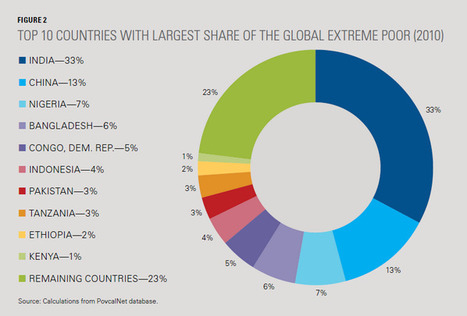
Where the extremely poor live | Geography Education | Scoop.it

A report by the world bank shows where the poorest live (defined as those that live on less than $1.25 a day).

The article below argues that maybe we should not be calculating development on just the economic gains a country makes.

http://www.theguardian.com/global-development/poverty-matters/2014/may/02/development-policy-human-rights

The power of photographs

It's amazing what a difference taking the same photo from different angle can make. This is why we have to be so careful when interpreting photographs and consider what can't be seen in the photo as well as what we can see.

This is the Taj Mahal

cool-places-world-perspective-India

The Taj Mahal from a slightly different angle...

 cool-places-world-perspective-river-trash

Link to some more famous places seen from slightly different perspectives

Monday, May 12, 2014

Yr 11 - Latitude and Longitude


 Here are some more videos which explain how to use latitude and longitude to find places on the earths surface.


Yr 13 - Global Patterns - 40 maps that help to explain the world.

(Imgur)

Maps are great tools when it comes to trying to understand the world around us!

You will also have to be able to interpret maps and describe and identify any patterns that they highlight.

Link to 40 maps that explain the world!

The link above has some interesting maps that could give you ideas of topics you may wish to examine for the global patterns Internal.

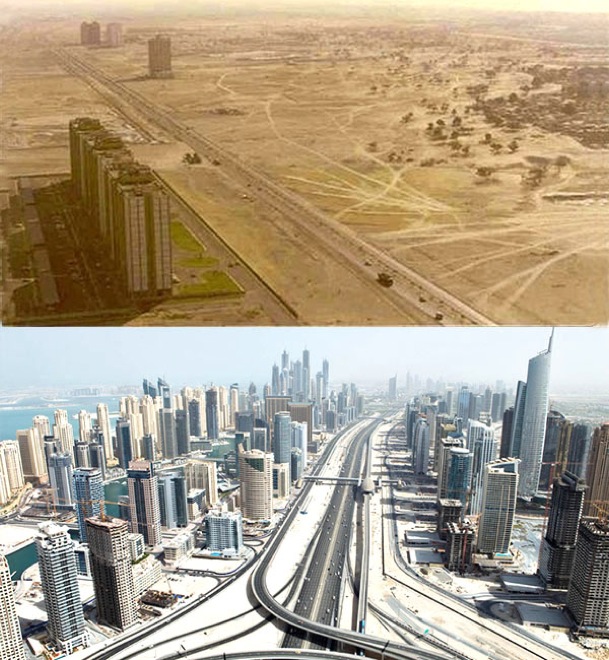
Pics to show just how much the world has changed in the last 20 years!

world-cities-before-after-2

The pictures above show Dubai in 1990 and then in 2013. The link below has more pictures that show just how quickly the urban areas are changing across the world.

http://justsomething.co/before-and-after-world/


Sunday, May 11, 2014

Yr13 - The Impacts of Tourism

Here are some of the videos we viewed in class last week showing the global impact of Tourism.

This one describes the impact of Tourism in Mallorca, Spain.


This one is from the CNN news channel and talks about the general Global Impact.


More general global impacts of Tourism.

Friday, May 9, 2014